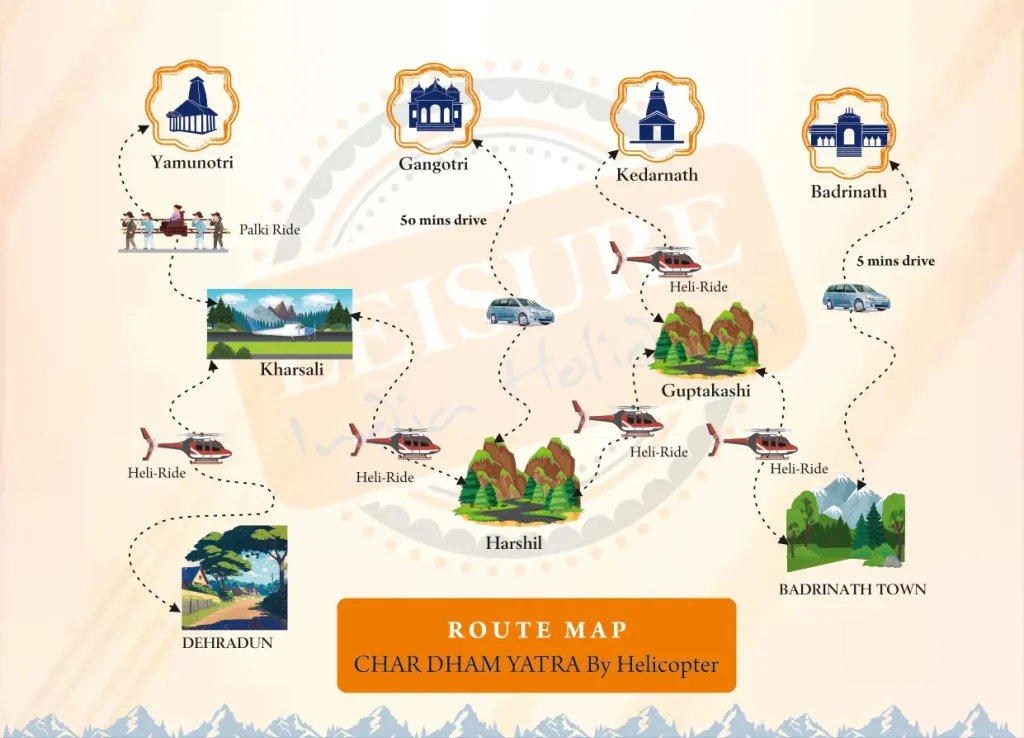
Chardham Yatra Route Map is also termed as the most crucial while organizing a pilgrimage tour of Uttarakhand. The tour covers four temples, which are sacred in nature—Yamunotri, Gangotri, Kedarnath, and Badrinath. People often say that the moment you reach these sacred temples, your mind feels calm, your heart relaxes, and life suddenly feels filled with pure happiness and peace. You can have a splendid journey with our Chardham Yatra by Helicopter tour. Also check our Do Dham Yatra by Helicopter Tour, to visit Kedarnath ji and Badrinath ji in one day.
Before you start the journey, it’s always good to know the route you’ll follow. The Chardham Yatra Route Map helps you see where to begin, how far each temple is from the next, and which places are good for short breaks along the way. When you understand the route in advance, the whole trip feels easier, smoother, and a lot more enjoyable.
Chardham Yatra Route Map of Starting Point
Most pilgrims start the yatra from Haridwar, Rishikesh, or Dehradun. All three places are convenient and make a perfect starting point for the journey ahead.
- In Haridwar, people usually begin their yatra by taking a peaceful holy dip in the Ganga and staying back to watch the beautiful evening aarti. The whole atmosphere feels calm, spiritual, and full of faith.
- Rishikesh: Peace and peaceful environment exist there. Yoga is practiced, and riverbank relaxation is enjoyed by people.
- Dehradun: If you travel by air, the local airport is the nearest option. Then taxi or bus can be reached there, and trekking is started.
Then Yamunotri is accessed through the route as given in Chardham Yatra Route Map.
Chardham Yatra Route Map of Yamunotri
Yamunotri is used as the start point. Temple of Goddess Yamuna exists there.
- Driving is possible up to Janki Chatti, which is also referred to as the road end point.
- There will be a 6 km walk, or pony or palanquin journey is on option.
- Approximately 210 km has to be covered from Haridwar.
- Yamunotri Temple, Surya Kund (hot spring), and Yamuna River stream are some key attractions.
As you can see on the Char Dham Yatra map, the journey begins with Yamunotri. Most pilgrims stay overnight so they can visit the temple and the hot springs early in the morning. The cool mountain air lifts your mood, and the whole place feels festive with excited travelers everywhere.
Chardham Yatra Route Map of Gangotri
The second one is Gangotri in the schedule. There Ganga puja is performed.
- It is much readily road-serviced, with a need to do only a very small walk.
- It is 230 km from Yamunotri.
- Make time to visit the main attractions here — Gangotri Temple, Gaumukh Glacier, and the Bhagirathi River, where many believe the holy Ganga starts its journey.
Gangotri sits surrounded by steep mountains, just as the 4 Dham Yatra map shows. The river flows gently beside you, snow glows on the peaks, and the cool wind touches your face. The whole place feels calm, pure, and almost other-worldly.
Chardham Yatra Route Map Kedarnath
Third is Kedarnath and is referred to as the toughest phase of the yatra.
- Last motorable road station is Gaurikund. 16 km trek from there to the temple.
- Helicopter service facility is also provided in case of walking inability.
- Road distance between Gangotri and Kedarnath by road is about 250 km.
- Scenic spots are Mandakini River, snow-clad mountains, and Himalayan terrain.
In 4 dham yatra map, Kedarnath has been indicated surrounded by hills and in a valley. The pilgrims are calm and contented on arrival here.
Chardham Yatra Route Map Badrinath
Pilgrims finish their Chardham Yatra at Badrinath, where they believe Lord Vishnu lives in his divine home.
- The temple is directly reachable by road.
- It is 220-225 km from Kedarnath.
- Badrinath Temple, Tapt Kund (hot spring), Mana Village, and Neelkanth Peak—these are some leading attractions.
The char dham route map shows the target point to be Badrinath. The pilgrims adore visiting all four temples. There are others who adore stopping at the riverside, offering their prayers, and viewing nature’s vistas.
Chardham Yatra Route Map of Total Distance
The whole yatra, if done and undertaken at Haridwar, is about 1,600 km long:
- Haridwar → Yamunotri: 210 k
- Yamunotri → Gangotri: 230 km
- Gangotri → Kedarnath (Gaurikund): 250 km + 16 km trek
- Kedarnath → Badrinath: 230 km
- Badrinath → Haridwar: 320 km
Map of the route of Chardham is planned wherein rest, lunch, and night stay has to be undertaken.
Chardham Yatra Route Map Travel Options
The Chardham Yatra Route Map can be covered in various ways:
- By Road: Pilgrims are facilitated by buses, jeeps, and taxis.
- By Helicopter: Quick and comfortable. The char dham yatra map pdf decides the landing and take off points.
- You can take a train to Haridwar, Rishikesh or Dehradun first and then continue the rest of the journey by road.
Chardham Yatra Route Map Best Time
The yatra path is accessible for almost six months of the year. Temples are closed in winter due to snowfall.
- Summer (May–June): Smooth road and good weather are enjoyed.
- Monsoon (July–August): One has to be careful as landslides may happen.
- Autumn (September–October): Peaceful atmosphere and light crowd are enjoyed.
Chardham Yatra Route Map Facilities
Gallore of facilities on the Chardham Yatra Route Map for tourists:
- Hotels, dharamshalas, and guesthouses for stay.
- Restaurants and food stalls for food.
- Medical assistance and emergency stops for treatment.
- Raincoat stores, woollen stores, medicines stores, and puja material stores.
Petrol pumps, ATMs, and emergency halting points are also marked on the char dham yatra map.
Chardham Yatra Route Map Tips
- Pack warm clothes because the mountains can get very cold at night, even in summer.
- Keep basic medicines for stomach pain and altitude sickness in your bag, so you stay comfortable on the way.
- Travel light, but always carry a raincoat, a small torch, and a few snacks for sudden hunger.
- Book your stay and travel plans before the Yatra rush starts, so your trip feels relaxed instead of stressful.
- Take your time, breathe in the beauty around you, and enjoy the journey — the Yatra is not just about reaching the temples, it’s about the experience you collect on the road.
Chardham Yatra Map Spiritual Significance
This route map is considered not to be roads as it considered to be a journey of heart and soul.
- Yamunotri represents innocence and fresh beginnings.
- Gangotri brings wisdom and peace of mind.
- Kedarnath inspires strength and deep devotion.
- Badrinath fills you with joy and a sense of inner peace.
After performing this pilgrimage, pilgrims get spiritually enlightened, peaceful, and happy.
Last Words on Chardham Yatra Route Map
People often call the Chardham Yatra Route Map a navigation map because it shows you the way clearly. Whether you look at the 4 Dham Yatra route map or download a Char Dham Yatra PDF map on your phone, understanding the route helps you travel safely and without fear.
If you’re a first-timer, the map guides you at every turn and if you’ve done the Yatra before, it reminds you of the mountains, rivers, and temples you already love.
Carry warm clothes for the cold weather, a few basic supplies, your prayers, and of course, the Chardham Yatra Route Map. With these in your bag and faith in your heart, the journey becomes a peaceful walk through nature and devotion. You can have a splendid journey with our Chardham Yatra by Helicopter tour. Also check our Do Dham Yatra by Helicopter Tour, to visit Kedarnath ji and Badrinath ji in one day.